
This material is a technical description of the climb of Mount Kazbek from Georgia along the classic route (difficulty PD, Russian 2A).
The program, cost, and organizational details of the guided climb can be found here.
Kazbek is one of the highest peaks of the Caucasus, and it is located on the territory of two countries – Russia and Georgia. It is about 5054 meters high. Once Kazbek was an active volcano, but the last time it erupted in 650 b.c. and now it is covered with glaciers. Nowadays it is one of the most popular mountaineering routes in the Caucasus. There are 2 possible climbing routes – from Russia and from Georgia. The most popular is the easiest one is from the Georgian side.
A first-hand story: one of our participants filmed his aspirational experience of climbing Kazbek in 2019:
The climbing route corresponds to the classification of 2A grade of difficulty. Also, from the Georgian side, there are several routes AD+/D- (Russian 3B) category of difficulty, but they are not so popular, and less visited. In this article, we will talk about the classic PD (Russian 2A) route.
Climbing season
High season
The first part of the high season: middle of July — end of August. This is the most comfortable time for climbing. Weather is the most stable. Most of the time — sunny days. A protracted period of rains is not seen — mainly storms that come one day. Temperature in Stepantsminda +20 … + 25, on top is -5 … 0. Glacier during this period the most open, all the cracks are visible. Often there are calm days when it is possible to sunbathe, even at the top.
The second part of the high season — September. In the first half of September, usually comes a series of cyclones, which bring precipitation in the form of snow at an altitude of 4000-5000 meters above sea level. After that the weather reminiscent of summer, however, the temperature falls to 5-10 degrees, it is felt especially at night. During this period, strong winds are possible at night.
Low Season
1. The second half of June—the first half of July;
2. October.
In the second half of June on the Kazbek is still «late spring» with her thunderstorms and precipitation in the form of rain, but there are already some windows of clear weather — the period of 2-3 days when the ascent is possible. At this time, the cracks are not all open, snow destroys «bridges» and you need to be extremely careful while traveling on the glaciers. The temperature is almost summerlike: +15 … 25 … in Stepantsminda and -10… 0 at the top.
October — late autumn with the inherent to this period prolonged rainfall and strong winds. Bad weather can stand even for a week. The temperature at the top can reach -15 … -20. The glacier is often covered with new snow, cracks partially sprinkled. There are strong winds at altitudes of 3500-5000 m.
The climb of Mount Kazbek in the off-season
November and winter months is a very cold and windy period. The temperature at the top of -20 … -35. Glacier — Ice bottle, often lightly sprinkled with snow. Strong winds at altitudes of 4000-5000 m.
An early spring — a time of precipitation and storms that can last several weeks. During this period can climb only «under the weather».
April and early May – the time of the «winter» skitour climb.
The second half of May and the first half of June are the time of heavy rainfalls, thunderstorms, and windy weather, which can last for several weeks with short breaks in relation to sunny weather.
Sections of the climbing route

The starting point of the route is the village Stepantsminda (Kazbegi).
The way to the Kazbek summit takes from 4 to 7 days, depending on the weather and physical condition of the group.
Elevation gain about 3500-3800 m.
The length of the route Stepantsminda-Kazbek-Stepantsminda: around 42 km.
GPS-track of the climb from the Georgian side.
The entire route is divided into several sections, which is primarily due to the convenience of places for overnight stays, water availability, and the need for acclimatization to the altitude. Some transitions have alternatives. In particular, the Gergeti church has the opportunity to ride by car (in Stepantsminda there are many drivers offering their services). In addition, to lighten the approach you can hire horses that will take backpacks with equipment directly to Bethlemi Hut. However, a common recommendation is — take acclimatization under load in order to be better prepared for the final assault on the summit.
The most convenient camping locations:
• Gergeti church (2150 m)
• Green overnights (3000 m)
• Bethlemi Hut (3650 m)
• White Cross (3850 m)
• Black Cross (3900 m)
• Lower Plateau (4300 m)
• Higher Plateau (4450 m)
Section: Stepantsminda (1750 m) – Gergeti Church (2150 m)
Hiking time: 2 hours
Path length: 4 km
Elevation gain: 400 m
Water: organized spring near the Gergeti Church
Location and the surface for the tent: flat grassy spot
From the central square of Stepantsminda (Kazbegi) follow the way to the village Gergeti, then you can choose: a steep dirt trail directly to the monastery or the flat car road. No water sources are available along the way, so store some in advance. The remaining time could be spent on acclimatization and to visit the church. Climbers often skip this part of the way, choosing a transfer by car. The road is asphalted and equipped with a parking place near the church. A private car can be left in the parking during the climb.


Section: Gergeti Church (2150 m) – Green overnights (3000 m)
Hiking time: from 3 hours
Path length: 7 km
Elevation gain: 850 m
Water: Water pipe near the camp space and the stream 20 m away.
Location and the surface for the tent: relatively flat, grassy spot.
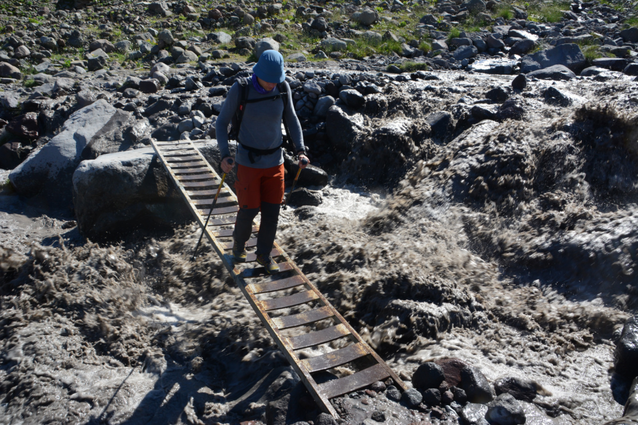
The smooth ascent goes on a gentle dirt trail with short steep sections to the Sabertse pass. Next, the trail goes to the river and crosses it. No water sources on the road, so it is worth taking some near the church. This section has no technical difficulties.


Section: Green overnights (3000 m) – Bethlemi Hut (3650 m)
Hiking time: 2 hours
Path length: 4 km
Elevation gain: 650 m
Water: Bethlemi Hut, glacier melted water
Location and the surface for the tent: flat rocky surface with wind protection walls or Bethlemi Hut
The flat rocky path leads to the tongue of the glacier. You traverse the Glacier of 10-15 degrees to the moraine. Then follow the steep scree trail to Bethlemi Hut. Be careful at the glacier — cracks are possible (but visible) around the main trail. In this case, using crampons and the rope is not required — but the final decision taken by the head of the group depending on the conditions of the glacier.


Section: Bethlemi Hut (3650 m) – White/Black Cross (3850/3900 m)
Hiking time: from 1 hour
Path length: 2 km
Elevation gain: 200-250 m
Water: glacier meltwater near the camp:
Location and the surface for the tent: flat stone ground with wind walls
From Bethlemi Hut follow the traverse stone trail with a few steep sections. The trail is marked with "cairns" (human-made piles of stones). In this area you should stick to the path, if you lose "cairns" out of sight, you should return to the last visible one.


Section: White/Black Cross (3850/3900 m) – Lower/Higher Plateau (4300/4450 m)
Hiking time: from 2 hours
Path length: from 3 km
Elevation gain: 350-550 m
Water: glacier meltwater near the camp, the snow.
Location and the surface for the tent: flat snowy spot.
One of the most difficult parts of the route. A stone path with elevation gain and loss of average steepness. This part of the route runs along the moraine dismembered with a lot of rocks and ice. There are few trails at the site, each marked with "Cairns" but often paths cross and are hard to see in the dark. Be especially careful in the area near the rockfall Khmaura. In summer, every few seconds a rock melts off the wall and falls down. After the moraine trail leads to the flat glacier. It is time to put on crampons and rope until the arrival at the campsite. You can find a place for bivouac near the trails. The place of the camp should be carefully examined for cracks. The shovel is necessary.


Section: Lower/Higher Plateau (4300/4450 m) – Kazbek summit (5054 m)
Hiking time: from 3 hours
Path length: 3-4 km
Elevation gain: 600-800 m
Water: glacier meltwater near the camp, snow
The trail in high season is a set of footprints in the snow and is almost always visible. With the elevation gain, the angle of the climb grows. The first difficult part — a steep climb to the saddle between the peaks of Great Kazbek and Little Kazbek. The second — the most important sector — the final steep slope to the top. The snow-ice slope with an incline of 30-40 degrees. In winter, there is no trail, often glacier ice is exposed, it is recommended to organize anchors, especially when climbing to the summit from the saddle.
The final climb to the top, you can make from Bethlemi Hut, White/Black Cross, or Lower/Higher Plateau, and it depends on the common physical conditions of the group and the weather. Typically, the assault is assigned in the range from 2 to 6 o’clock in the morning, depending on the overnight position. The higher the base camp, the later you can go. The descent from the summit on the same route and takes from 2 to 5 hours (depending on the location of the camp). The day after the climb, most of the groups descend directly to Stepantsminda.


Planning the climb to Kazbek, useful information
Transfer
a) Tbilisi — Stepantsminda (Kazbegi)
Distance from Tbilisi to Stepantsminda: 155 km. By car — 2.5-3 hours.
Transfer by shuttle bus: 10 GEL. Minibus starts from the metro station «Didube». The schedule is floating. The first bus leaves at about 9 am and then at intervals of 1 hour with a break from 12:00 to 15:00. Sometimes there is an additional 5 GEL fee for luggage.
A private car for 3-4 people costs from 100 GEL, a minibus for 5-7 people from 150 GEL. The price is one way.
b) Kutaisi — Stepantsminda (Kazbegi)
Distance from Kutaisi to Stepantsminda: 330 km. By car -7-8 hours.
Minibus Kutaisi (city) — Tbilisi (Didube): from 10 GEL, then transfer with a minibus to Stepentsminda.
Direct bus from GeorgianBus — from 55 GEL per person. Tickets can be pre-booked on the company’s website.
Currency exchange and payment for services
The national currency of Georgia is GEL. We recommend exchanging the required amount in Tbilisi. Payments by cards are partially possible in cafés, restaurants, and hotels in Stepantsminda. Payments for horse rental and accommodation in Betlemi Hut - only in cash.
Equipment rental
The best option would be to rent climbing equipment in your hometown. There are also several rental points in Georgia.
In Tbilisi:
MPlus
It is worthwhile to write them in advance and book the necessary equipment.
In Stepantsminda:
The cost of one item (for example crampons): 10 GEL per day. However, you can negotiate a discount, if several sets of equipment are taken at least for a period of 5 days.
The stock is large enough cats, ice axes, harnesses, ropes, tents, mats, etc. Condition of equipment is good enough: it is clear that it was in use, but works well. The exceptions are the shoes. Your size may not be in stock. So please take care of them earlier in your hometown.
Gas balloons
According to the rules, you can not transport gas balloons on a plane. You can purchase them in Tbilisi stores The North Face, MPlus, Xtreme и SportMaster.
Addresses:
The North Face: Tbilisi, Adam Mitskevichi 68
The North Face: Tbilisi, Vazha Pshavela 10
The North Face: Tbilisi, Shota Rustaveli 2/4
MPlus: Tbilisi, Vazha Pshavela 25
Xtreme: Tbilisi, Akaki Beliashvili 85
SportMaster: Tbilisi, Roman Miminoshvili 6
The price is 30-45 GEL per balloon.
The price is pretty the same in Stepanstminda.
Rescue Service
Short number Rescue Service in Georgia: 112
Registration for the climb is carried out at Bethlemi Hut. You need to go to the administration room and register for the whole group. We recommend you notify the rescuers once again the day before the climb.
Shelters booking
There are two shelters on the way up. AltiHut (3014 m) and Bethlemi Hut (3650 m).
Weather forecast
The most accurate weather forecast is meteoblue. We recommend watching the weather both at Stepantsminda and at the summit itself. The forecast is updated twice a day: at noon and midnight.
Phone network and Internet coverage
The phone steadily catches the network (4G) from Stepantsminda to Bethlemi Hut. Also, a good connection around the White Cross. Then the connection disappears and appears only at the top of the Mountain (sometimes you need to go down towards Stepantsminda 5-15 m).
Recommended gear
• Hardshell jacket (Gore-Tex or similar)
• Hardshell pants (Gore-Tex or similar)
• Warm down jacket
• Warm synthetic insulated jacket(e.g. Primaloft or fleece)
• Light jacket(fleece/Primaloft or similar)
• Warm pants (down, fleece, Primaloft, or similar)
• Hiking pants
• Thermal underwear (2 sets)
• Thermal socks (3–4 pairs)
• Mittens/warm gloves
• Liners
• Warm hat
• balaclava/buff
• T-shirt
• Mountaineering boots (or hiking boots with warm insulation)
• Spare approach shoes (light hiking shoes)
• Sleeping bag with comfort limits −5 ... −10 °C (+23...+14 °F)
• Inflatable sleeping pad with R-value 2 or higher
• Backpack (60–70 L)
• Raincover
• Personal tableware (mug, bowl, spoon, knife)
• Telescopic poles
• Thermos
• Sunglasses (factor 3)
• Sunscreen (SPF 50+)
• Sunscreen lipstick (SPF 20+)
• Headlamp + spare batteries
• Personal hygiene products
• Personal first aid kit
• Crampons
• Ice axe
• Harness
• Locking carabiners (2 pcs.)
• Cow’s tail, safety chain, or similar
• Helmet
• Prusik cord
• Dynamic rope 50-60 m
• Ice screws 3-4 pcs.*
• Quickdraws (2-3 pcs.) *
• Slings 120 cm (2 pcs.)*
• Tibloc or similar *
• Micro Traction *
• Cord 6-7 mm, 7-8 meters *
• Spare cord 6-7 mm *
• Locking carabiners (3-4 pcs.) *
• Non-locking carabiners (3 - 4 pcs.) *
* This equipment is necessary for:
- for effective crevasse rescue operations when one of the participants falls into a crevasse
- to secure and fix the rope on the section from the saddle to the top in dangerous conditions of the route (icy conditions)
In addition to group equipment, a GPS navigator with a loaded route track will be required.
If you have a big group, it will be quite useful to have a radio for easy communication between the group or with the camp. If you plan to spend a night at the Lower/Higher Plateau, you should bring an avalanche shovel for making wind walls and preparing a surface for a tent.
IMPORTANT! During the winter climb, the list of equipment increases: it is worth taking 5-7 ice screws, 5-7 quickdraws, and several additional slings of 60-180 cm. An avalanche beacon, probe, and avalanche shovel are required for each participant.